
Friday was a very active weather day in Minnesota with several confirmed tornadoes, including one in the Twin Cities Metropolitan area as of Sunday morning. Please note that some information may be updated, adjusted, or added in the coming days if additional surveys are conducted by the National Weather Service. Below is a breakdown of the information provided by the Twin Cities National Weather Service for tornadoes.
Crystal:
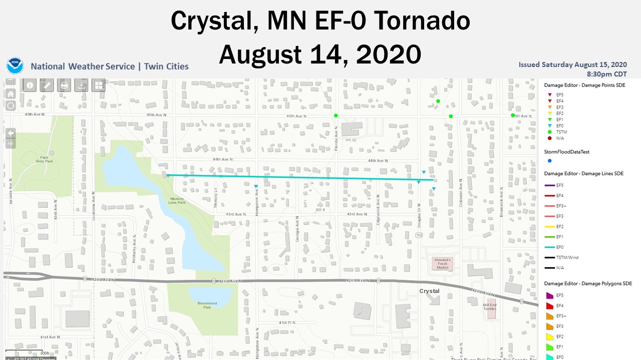
The National Weather Service has confirmed that an EF-0 tornado briefly moved across the city of Crystal on Friday evening. This tornado started off near Memory Lane Park between 43rd and 44th Avenue North and Jersey Avenue North. A large tree was uprooted as a result of this tornado. The tornado moved eastward between 43rd and 44th and damaged several large trees that were up to 4 feet in diameter along its path. The tornado lifted near Douglas Drive North in Crystal. Some roof damage occurred as a result of this tornado. A majority of the trees and large limbs fell on power lines, roads, and yards as well. More isolated damage was located on 45th Avenue North, but the damage was consistent with downburst winds and was more sporadic, according to the National Weather Service. This tornado had estimated peak winds at around 75 MPH, a path length of about .4 miles, and a path width of around 50 yards. It is estimated to have started at 7:55 PM and ended at 7:57 PM. Thankfully no injuries or fatalities have been reported from this event. The graphic below from the National Weather Service shows the plotting of the tornado.
McLeod County:
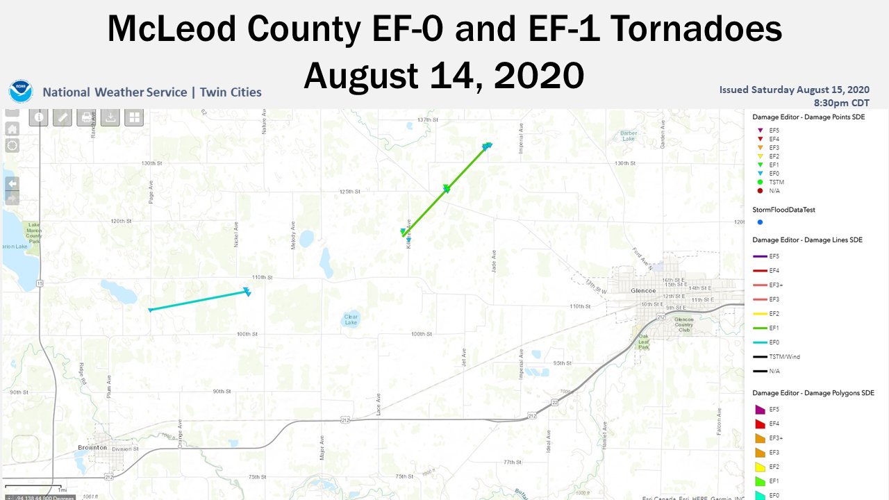
The National Weather Service confirmed that two tornadoes touched down in McLeod County on Friday. North of Brownton in McLeod County, a National Weather Service Damage Survey found damage consistent with an EF-0 tornado. Several trees were snapped, a trailer was overturned, and a metal grain silo wall was damaged and collapsed. Many photos and videos of this particular tornado shared on social media also were used to confirm this. This tornado started about two miles north of Brownton and ended about 3.5 miles northeast of Brownton with a path length of about 1.75 miles and about 300 yards wide. The estimated peak winds in this tornado are about 85 MPH. This tornado is estimated to have started at 5:45 PM with an end time of 5:49 PM. Thankfully no injuries or fatalities have been reported from this event.
Another tornado was confirmed in McLeod County between Biscay and Glencoe on Friday. An NWS Survey found damage consistent with an EF-1 tornado. Maximum wind speeds of 95 MPH snapped and uprooted trees and damaged buildings within this area. Many photos and videos of this tornado were also shared on social media, which helped in the process. This tornado is estimated to have had a length of 2.25 miles with a width of 250 yards along with a start time of 5:50 PM and an end time of 6:01 PM. Thankfully no injuries or fatalities have been reported from this event. The graphic below from the National Weather Service shows the plotting of the tornado.
Waconia:
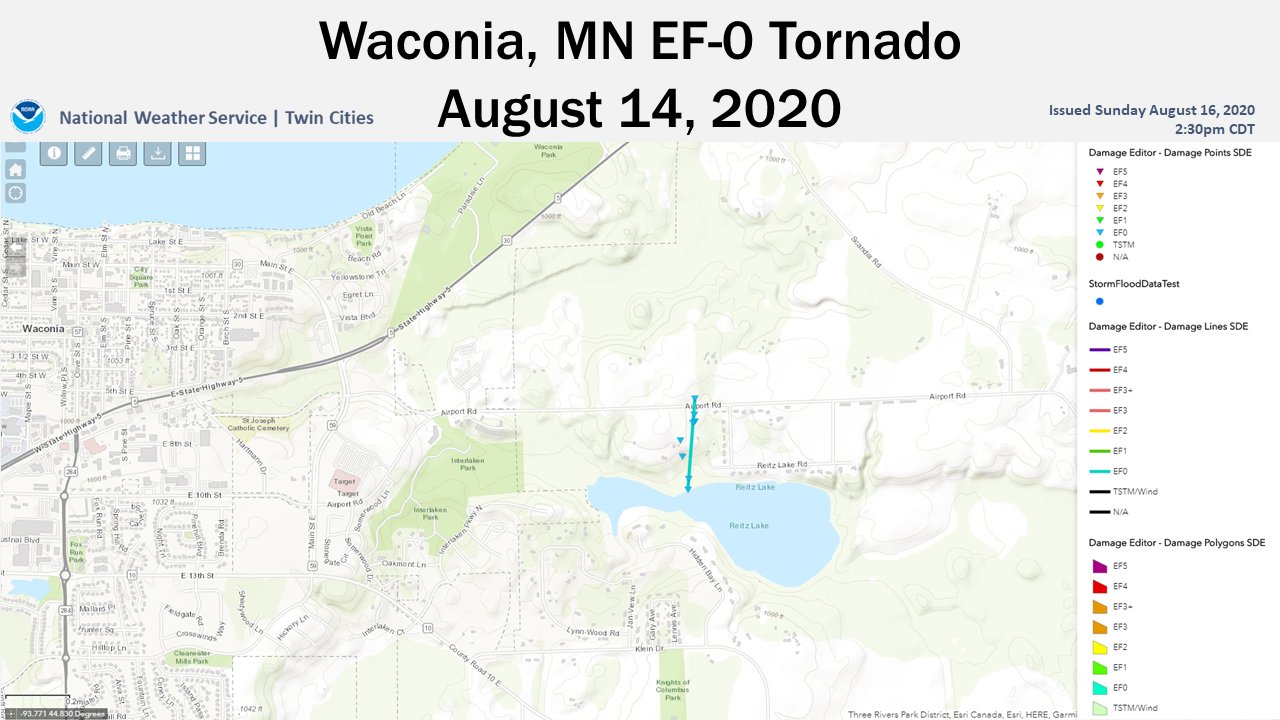
The National Weather Service confirmed that a brief EF-0 tornado touched down just offshore on the western edge of Reitz Lake and moved inland. Damage from this tornado was seen on a boat lift, boat, and several trees before it dissipated just north of Airport Road. The tornado had an estimated peak wind of 70 MPH with a path length of roughly .30 miles and a width of 50 yards. It is believed to have started around 6:49 PM and ended shortly after, around 6:50 PM. Thankfully no injuries or fatalities have been reported from this event. The graphic below from the National Weather Service shows the plotting of the tornado.
Spicer/Green Lake:
A National Weather Service Survey found EF-0 tornado damage along and south of Green
Lake in Spicer, MN. Docks along the lake received damage, as well as several trees were snapped by this tornado. A report was received that a restaurant lost its roof. The surveyor was unable to contact the owner when this event was surveyed. The NWS did say that the path may be updated once more information becomes available. This tornado had an estimated peak wind of 70 MPH, a path of 3.4 miles, and a path width of 50 yards. It is believed that this tornado started around 5:41 PM, about .75 miles south of Spicer, and ended at 5:47 PM in Green Lake. No graphic of this tornado was available at the time of the creation of this blog. Thankfully no injuries or fatalities have been reported from this event.
Kandiyohi/Meeker County:
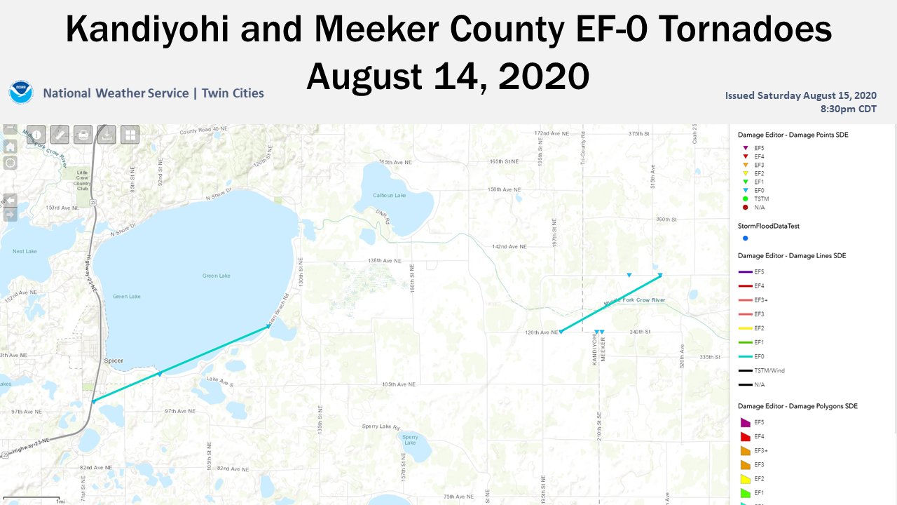
A National Weather Service Survey found EF-0 tornado damage along the Kandiyohi and
Meeker County border. Numerous trees were either snapped or uprooted as a result of this tornado. Much of the path was inaccessible to NWS Surveyors. The NWS noted that the track might be updated once more information becomes available. This tornado has an estimated 2-mile path length with a width of 50 yards, estimated peak winds of 85 MPH, and a time frame of 5:53 PM to 5:58 PM. The NWS stated that the tornado started near 195th St NE and 120th Ave NE and ended near the Crow River. Thankfully no injuries or fatalities have been reported from this event. The graphic below from the National Weather Service shows the plotting of the tornado.
Additional Information:
You can always stay ahead of the storm with our Live Interactive Radar on our website! As more information becomes available regarding these tornadoes, this blog may update. More information can be found on the National Weather Service website if you are interested. If you have any photos from these storms, feel free to share them with us on Facebook, Twitter, or by emailing us!