
THIS BLOG WILL BE UPDATED THROUGH THE DAY ON FRIDAY AND SATURDAY.Last Updated: 6:51 PM 1/16/2020
OVERVIEW: After our frigid temperatures on Thursday with wind chill values past -30° in Northern Minnesota, our next big weather story will be heavy snow. This winter storm will impact the entire state of Minnesota, with the bullseye being focused around the Twin Cities and surrounding areas.
ALERTS: A Winter Storm Warning has been issued for most of Minnesota Friday morning into Saturday evening for this storm. There is a possibility of some parts of the area getting upgraded to a Blizzard Warning on Saturday if currently forecasted winds of 40 to 45 MPH stay on track, according to the National Weather Service.
TIMING: Snow will start to develop and move into the area Friday morning and last into Friday evening. This snow could be heavy at times, with rates of 1″ – 1.5″ of snow per hour possible in some areas. Off and on snow is the forecast for Friday night into early Saturday morning as the snow moves on out. Even though the snow will be away, the winds will start to crank up and blow the fresh snow around, creating travel hazards and near-whiteout conditions on Saturday. Winds from the northwest at 20 – 40 MPH with gusts of near 50 MPH will make for a dangerous Saturday. Temperatures will continue to fall on Saturday as well, creating negative wind chill values during the day.
IMPACTS: Travel will be difficult Friday into Saturday, not just due to the snowfall that we get, but the snowfall will be wind-whipped on Saturday. Traveling is not recommended Friday afternoon into Saturday evening. The heaviest snow will fall Friday afternoon for most locations, with snowfall rates of 1 to 1.5 inches per hour at times.
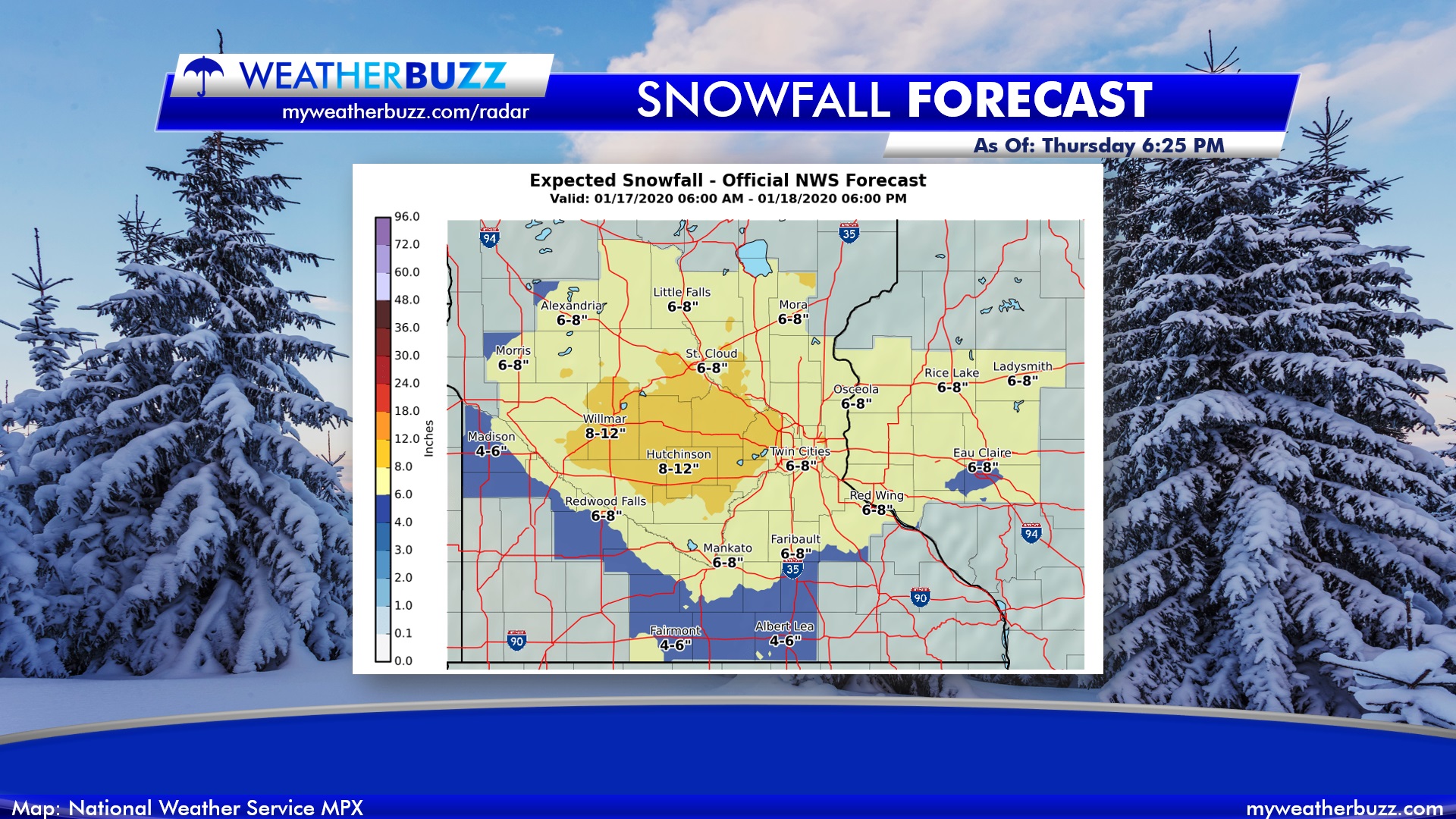
TOTALS: Widespread amounts of 6″ – 10″ of snow are looking very likely for most of the area for this winter storm. Heavier totals as of Thursday afternoon appear to be off toward areas like Hutchinson, Wilmar, Buffalo, and Litchfield. The snow will fall late Friday morning into Friday evening. The graphic below shows the expected snowfall totals as of Thursday afternoon from the National Weather Service in the Twin Cities.
Always remember, you can track this heavy snow using our Live HD Interactive Radar by clicking here. Send us your snowfall pictures and totals by email or on Facebook too! 🌨⛄☃🌧☔🧊❄